I'm posting my previous series on the Shomron (Samaria, aka "Northern West Bank") here as a single posting for linking purposes.
The Ride to Shchem
The
Belzer Beis Hamedrash Hagadol was fun, but now it's time for another adventure into the Jewish heartland, the
Shomron (Samaria; northern west bank.) At
Machon Meir, the semester ends on Tisha
B'Av (the ninth of Av, a day of fasting mourning for the destruction of the Holy Temple, which is coming up in just a couple of weeks,) so everyone came on the end-of-the-semester
shabbaton to get to know the new guys, and to say goodbye to those who will be moving on.
 Adam shows up, with guitar, of course!

 Deep in discussion.
The bus is here, "Central Corporation for the Development of the
Shomron, for the Settlements of the
Shomron and it's Settlement" (it sounds better in Hebrew.) This is one of the luxury models, air conditioned
and bullet proof.
An hour or so later:
 Coming to Givat Assaf, an outpost of Beit El, to pick up Rabbi Listman (director of the English Department) and family.
 And we'll be making a left turn, onward to Shchem! (Nablus.)
Along the way, we pass by several Arab villages. All of the homes visible from the road are far larger than anything the permitted to the Jews. Tennis courts, swimming pools, marble fountains, you name it. This highlights one of the major misconceptions about third world, in this case Arab society; that there is less money in the third world. Average income is not so much lower in the third world than it is in the first, but it's the wildly uneven distribution of wealth due to corruption which results in some people living in truly abject poverty. In this case, the Palestinian Authority does not have the vast mineral resources of their brethren in Saudi Arabia or the Gulf states, but it does have one major ace up it's sleeve; terror. Fear of being the victim of Islamic atrocities has led the states of Europe and Arabia to flood the Palestinian Authority with cash. Despite an alleged withholding of aid after the election of
Hamas a year ago, the Palestinian Authority still managed to rake in a cool $1.2 billion last year, that for a population of only a few million. Of course, every penny of this stays in the hands of whatever gangster warlords happen to be in power, hence the mansions.
The pictures didn't come out so great, as I was trying to photograph from the bus window. Much more impressive photos than these can be found at Shiloh
Musing's post:
Arab Mansions.


 Amber waves of grain south of Shiloh, where the Mishkan (the portable tabernacle, which preceded the building of the Holy Temple in Jerusalem) stood for 369 years.
We pass through
Hurwa (an Arab city built on the ruins of the ancient Jewish city of
Horon,) and are bombarded by billboards for falafel,
internet stock trading, you name it.
 "Please, send us more aid, we are on the verge of starvation! And our stock portfolios need diversification!"

Arriving at the traffic circle at the entrance to
Shechem, one is confronted with the grim reality of the price of ruling over a third-world society. The entrance to
Shechem itself (which the Arabs have renamed
Nablus,) is blocked and controlled, as are the off-ramps to the various towns and villages along the way. This is how the
IDF (Israeli Army) defeated the second
Intifadah, by controlling movement. With the ability to shut down transportation, the
IDF can stop the movement of suicide bombers upon the receipt of an intelligence warning.
As Israel surrenders the moral high ground, refusing to state its own case for it's right to posses the
Shomron, this provides encouragement to the Arabs that the Jewish will is weakening, and that terrorist atrocities will work to accelerate the Israeli collapse. This terrorism forces Israel to re-take full control of the roads. These checkpoints also prevent Jews from entering
Shchem to pray at the tomb of
Yosef Hatzaddik (the biblical Joseph) and his sons,
Menashe and Ephraim.

It's easier to pass through by foot, so a line taxis wait outside to pick up pedestrians and bring them to their next destination.


As for us, we'll be making a left turn and heading up to
Har Grizzim,
Grizzim Mountan, where Joshua first took the Jewish people upon entering the land of Israel to reaffirm the covenant.
Mayim Chayim
Previous Posts:
Part I:
The Ride to ShchemWe arrived at a natural spring on the slopes of Mount Grizzim, in the Gai Yosef (the Valley of Joseph.) This spring is one of the few in Israel which is considered "Mayim Chayyim," living waters, i.e. a spring which flows continuously.

Mayim Chayim have special properties in Halachah (Jewish practice.) Most Mikvahs (purification baths) have two chambers, one below which holds some form of natural water (spring water, rain water, well water, etc.,) and one above which contains chlorinated or tap water. The section of natural water below maintains its purity and transmits this purity to the upper waters. However, the lower section must hold a minimum volume of natural water to be able to maintain its purity.
Mayim Chayim has no such minimum volume requirement and may be used in any volume sufficient for complete immersion.
 This basin would actually be considered a kosher mikvah, if a person were able to fit into it. Well, maybe it's a dog mikvah.
The locals have built a small mikvah out of cinderblock and corrugated aluminum. Some of the guys jump in for a pre-shabbat dip.

There is one other use for Mayim Chayim: The preparation of the ashes of the Parah Adumah; the Red Heifer (cow.) In the Torah portion of Chukat, which we read a few weeks ago, God delivers the commandment to prepare the ashes of a Parah Adumah, which must not have more than one non-red hair on its entire body to be considered kosher. It must never have borne a yoke and must be blemish-free.
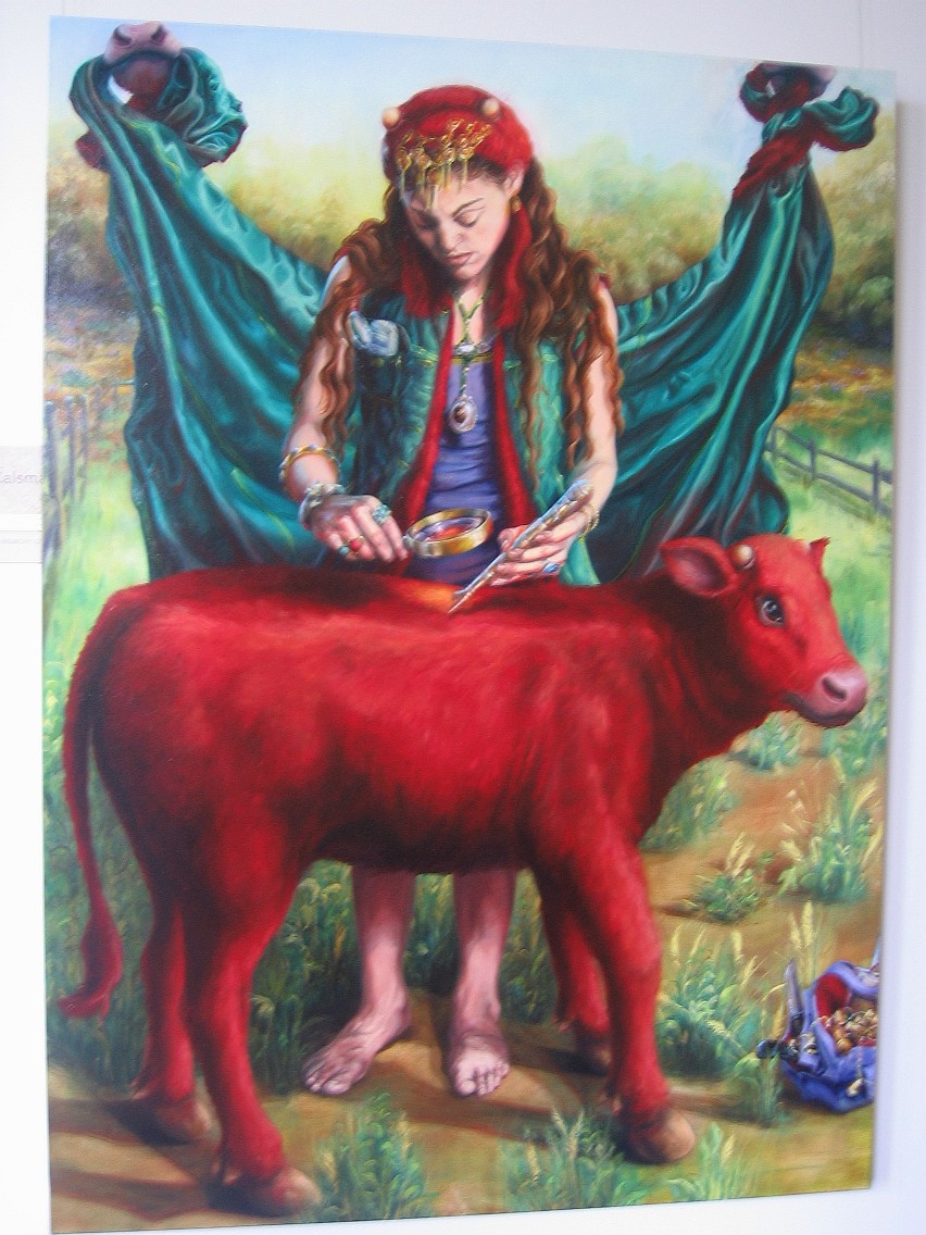 Inspection of the Parah Adumah.
 The Parah Adumah is then sacrificed, and its ashes mixed with Mayim Chayim. This Parah Adumah water is then sprinkled over those who wish to ascend to the Temple Mount, both during its construction and later to bring sacrifices once the Holy Temple is functioning.
 Preparing cattle for sacrifice.
Only two kosher red heifers have been recorded throughout Jewish history. Because we do not have a red heifer, we can not ascend the Temple Mount to remove the structure that is there now and rebuild our destroyed Temple. Of course, based on the stance of the current government, we'd probably have to have new elections too. And a few other things will have to happen first in addition to this. Still, for this reason, the birth of a Parah Adumah will be seen as one of the signs of the coming redemption.
One strange facet of the law of the Parah Adumah: while those who receive the mayim chayim and parah adumah ash mixture are purified, those involved in the preparation are rendered impure. This law is considered to be the most impenetrable law of the Torah, and is given as the paradigm of chukim, the types of commandments which we accept on faith, without complete understanding of their deeper implications.
 The Mishkan (Tabernacle) in operation
Not only is Mayim Chayim used for purification and for the making of the parah adumah water, I seem to have discovered a third use on my own:
 Nothin' like mayim chayim on a hot day.
On Mount Grizzim
We took a break for lunch on Mount Grizzim.

Jewish settler / country bumpkins trying to start their scooter.
The mayim chayim spring in the valley of Yosef trickles down and feeds a small grove of trees, which provided a nice shady spot for lunch.

The tree we sat under happened to be a mulberry tree, so some of us got a free desert.
 Bentching (reciting grace after the meal) in the mulberry tree.
 Mulberries!
The break gave me a chance to play with the macro mode on my new camera, photographing some of the flora, albeit with the admonishment, "Don't wander off too far. Some of the neighbors here can be unfriendly."
You can click on the photos to see larger versions.
 Mulberries on the branch.
 You probably don't want to eat these particular berries.


 Looking towards the bypass road to Itamar and Elon Moreh.
There was some sort of thorny bush, very blue, which caught my interest.
 Close...
 Closer...
 Closer...
 Closest.
 If I were one of these Israeli naturalist types, I could tell you the names of every species of plant, and probably even of this insect too. For the time being, however, I'm just an ignorant new oleh, so we will have to call him Mike.
 Thistles before blooming.
Before bloom.
 Thistles after blooming.
 After bloom.
 Some sort of beetle, getting lost on a flower.
 And here's the view of Itamar, which will be our next stop!
Itamar
 Yours truly, Itamar behind me.
We arrived in Itamar, unloaded from the bus, and were herded to the top of the hill.

Uh... what are we doing?
 Made it to the top first, with my new binoculars.
Our guide, Menachem, gave us a brief rundown on the origins of Itamar. The place was actually founded by a garin (seed) group of yeshiva students from our very own Machon Meir. Originally, they had wanted to name it Tel Chayim (the hill of life,) but the government was opposed because there were already too many places with similar names. Looking through the pages of the Tanach, they realized that Itamar, son of Aharon the Cohen (and nephew of Moses himself) was buried a few kilometers down the road, in what is now the Arab village of Awarta. The name Itamar stuck.

At the top of the more heavily settled section of Itamar one finds the ancient ruins typical of almost every hilltop in Israel. Sifting through the rocks and rubble on the ground, one finds shards of loose pottery all around.
 A piece of a pitcher handle.
 Pottery shards strewn about.
Moving higher on the hill, one comes to an ancient mikvah. One way of proving the Jewishness of particular ancient ruins is to find a mikvah. In this case, there is evidence of two layers of civilization. First, one finds a mikvah, meeting the requirements of Jewish Halachah. However, notice on the bottom left of the entrance there seem to be the remains of steps. However, the steps were later removed. It seems clear that this was originally a Jewish settlement, but later civilizations had no use for the mikvah and so chiseled off the steps, turning it into a cistern. Cisterns do not require steps because one need only drop in a bucket from above rather than completely immerse one's body.
 A mikvah, hewn from the stones. You can see the remnants of the steps on the bottom left vertical wall.
Chisel marks pointing down and to the left, which would indicate that the chiseler was left handed. Also note the traced edges of the former steps.
 Rebuilt terraces.
 Another mikvah.
But today, Itamar is again a thriving Jewish settlement.
 Flowers on fruit-bearing cacti.
 A small farm house. On the next ridgeline is Awarta.

Afterwards we descend back to the more "thickly" settled area of Itamar. "Thickly settled," is, of course, a relative term out here.
 Clusters of houses in Itamar, with Mount Eval seen in the background.
 The modest homes of Itamar.
Unlike the neighboring community of Elon Moreh, Itamar subsists largely on agriculture. However, growing edible foods on the barren hilltops has proved to be much more challenging than in the valleys below. Our next stop is an organic hilltop farm.
Organic Agriculture
Settlements like
Maaleh Adumim and
Kochav Yaakov have experienced rapid growth over the years due to their proximity to Jerusalem, providing them with the ample employment and cultural benefits of city life. In the hills of northern
Shomron, 40 minutes' drive from coastal cities like
Netanya, 40 minutes being an eternity in Israel, each community has had to find creative ways of self-sufficiency. In
Itamar's case, the settlers turned to agriculture.
Shchem (
Nablus) has sprawled outward and already consumed all the arable land in the valleys, so the settlers had to explore new forms of agriculture.

Alon Zimmerman's hilltop farm.
Because Arabs can not sell land to Jews on pain of death at the hands of their brethren, Itamar has focused on transforming the rocky, dead hilltops into productive agricultural land.

Yours truly, in front of
Itamar.
our tour of Alon Zimmerman's farm included new fruits in the
hothouses. The hothouses provide protection from the strong winds of the exposed hilltops, and provide enough heat to grow trees which would otherwise not survive the harsh environment.
 Entering the hothouses.
Alon shows us his products.
 Drip irrigation

Apples. These are still "
orlah" (covered.) A Jew is required not to touch fruit-bearing trees until the third year after their planting.

Al agriculture is organic, without hazardous pesticides. "Previous conquerors demonstrated that they did not hold the land holy because the agriculture they practiced destroyed it. When the Crusaders conquered
Eretz Yisrael, they planted sugar cane. Within three years the sugar cane had completely stripped the soil of its nutrients." Later, he doesn't add, the nomadic Arabs defeated the Crusaders and overgrazed the area.
The
Tanach speaks of the great forests which once carpeted the hills and valleys of the
Shomron. While today the land outside of Jewish settlements is completely barren and devoid of trees, the name of a nearby Arab village attests to the once plentiful lumber. The village is named
Hattib, Arabic for "cut," which implies a village of woodcutters. Historical records indicate that the last trees in the
Shomron were felled by the Ottoman Empire during World War I in a failed attempt to build a rail line to reinforce their retreating troops. With the disappearance of the forests which once blanketed the
Shomron, the winds carried away precious topsoil and exposed the rocks which lay beneath.
 The forests are slowly returning to the Shomron within Jewish settlements.
"We find that God rewards those who respect the land. Since we started using organic techniques, every year, we have harvested more and more."
 Strawberry patches.
 Strawberries. I've never tasted anything so sweet. As if they had already been dipped in sugar.
Next year, starting in
Rosh Hashannah, will be a
Shmittah, or sabbatical year. During the
Shmittah year, which comes every seven years, all land lays fallow, a sort of sabbath for the soil. There is a controversial
halachic loophole,
Heter Mechirah, which permits the temporary sale of land to a
goy (Jews are permitted to work land owned by
goyim,) in order to prevent famine or loss of the land. Hydroponic farming is permitted during
Shmittah since the crops do not come into contact with the soil.
"It's a difficult decision, and I'm still not sure what I'm going to do. I might have to do
heter mechirah. Of course," he says, glancing at a massive rainwater collection pond he built, "I've been thinking of
hydrophonic or fish farming, so maybe I'll take a year and try that out."
 Perhaps hydroponic gardening is the answer?
The greatest challenge yet came not from
Shmittah but from the Arabs, during the Intifada. It started in September of 2000, right at harvest time.
"One day, the truck just didn't come to take our tomatoes to market. I called the truck driver. He was terrified to come out here. I really didn't know what to do. It seemed like all my crops were going to sit and rot. That night I talked with my wife. All our wives got together, and they started playing with recipes. Pretty soon, they had figured out how to make pasta sauces, sun dried tomatoes, and preserves. Things that would last on the shelves. We opened a factory on the settlement, and were able to save the crop."
Alon's success has been replicated on many of the hilltops of
Itamar, stretching out over mile after mile of the once barren hilltops.

Next stop... Hill 851.
The Hilltops of Itamar
As hostile political winds continue to blow against the existence of Jews beyond the 1949 armistice or "green" line, today's version of Czarist Russia's "Pale of Settlement," each settlement has to adopt its own strategy for survival. In the case of
Itamar, not near the green line and far from the security fence, the strategy has focused on holding the line against encroachment from neighboring
Beit Furik to the north and
Awarta to the south by holding hilltops on the outer periphery of its
jurisdictional area. This keeps the center clearly in Jewish hands for future growth. Ten kilometers to the east, an enormous distance by Israeli standards, lies the Jordan River Valley. Sparsely populated, ringed by cliffs capable of stopping any tank assault, the Jordan Valley has consistently been considered a "consensus area," i.e., an area which most Israelis believe should remain under Israeli control under any outcome.
Itamar's strategy has been to spread eastward, building small outposts on hilltop after hilltop, to create a contiguous area of Jewish sovereignty all the way back to the Jordan Valley.
 A map from Peace Now's list of outposts which it is demanding be destroyed. I've circled the chain of hilltops claimed by Itamar.
Hilltops appear on topographical maps as small "+" symbols followed by the elevation in meters. These elevations are used as temporary names for outposts. The first
hilltop we will visit is at 851 meters, hence it's name "Hill 851."
 Foreground: the more densely populated section of Itamar. Background: hilltop outposts.
"This road," Menachem, our resident guide tells us, "was built five or six times. We would sneak out here with the tractors at night. The next day the army would find it and destroy it. Then we'd build again, and they would destroy again. Eventually, they got tired of destroying it, and now they actually use it for patrols."
Our bus begins its ascent, weighted down with a full load of students, steel armor plating and bullet-proof glass, the motor begins overheating. But onward we go!
 Chabad of Itamar, under construction.
Eventually we arrive at hill 851.
 Some soldiers guarding hill 851.
 I thought that was a pretty cool pic, so here's a zoomed-in version.
The outpost itself isn't much to write home about. A few ramshakle houses, mostly built up log-cabin type skins over trailer interiors. But hill 851 provides a strategic view over Shchem (Nablus,) which has always been a hotbed of terror.
 A boychik soldier in his base. He was happy to pose for photographs.
 Yours truly, looking from the bunker out over Beit Furik.
 A trailer converted to a log cabin.

Scattered houses of Hill 851
While wandering around Hill 851, we find a modest shrine, labeled, "Tomb of
Gidon the Judge."
"When we were building the outpost, there were a few stones stacked up on this spot. Nothing major. We accidentally bumped into them with a bulldozer and knocked them over. We didn't think much of it, but the woman who was driving the bulldozer had recurring nightmares that she had destroyed something important. When they didn't go away, we took her to some of the major kabbalists. They told her that she had demolished the grave of Gid'on Hashofet (Gideon the Judge, whose leadership in war is described in the book of Judges.) We built this little shrine for him. We don't have any external proof or long-standing traditions about this gravesite. Still, it's nice to have."
 Menachem, Itamar resident, Mahon Meir graduate, and our guide.
"
Tzedukkah (Charity) for
Gid'on HaShofet"

The "Grave" of
Gid'on HaShofet Rav Listman
, "This is ten times bigger than the trailers at
my outpost."
Continuing along, we passed through several similar hilltop outposts, some more and some less developed.
 Further up: It's a windy day at the Givot Olam outpost.
A tourist attraction out here in the middle of nowhere, the "Three Seas" tower. From the top of the tower, on a clear day, one can see the Mediterranean Sea, the Dead Sea, and the Sea of Galilee.
 And more and more and more hilltops. Itamar seems to go on forever.
The View from Hill 851
From the bunker on hill 851, one can look out eastward over the
Dagan Valley, which is capped on both ends by the villages of
Beit Furik and
Beit Dajan.
Beit Dajan is built over the ruins of the ancient Jewish village of
Beit Dagan, the "House of Grain," mentioned in the Talmud as one of the great breadbaskets of
Eretz Yisrael.
 Beit Furik (foreground) and Beit Dajan (background)
When Israel first captured this area in 1967,
Beit Dajan and
Beit Furik were in the same situation as
Beit Jann in the Galilee. Dependent on natural springs and rainwater for all drinking and agricultural water, the town was severely limited in size. Building technology was, as it had been for centuries in the land, dependent upon simple stone masonry, and agricultural technology had not changed much over the centuries. From 1948 through 1967, during the Jordanian occupation, approximately 200,000 Arabs moved from what would later be called the "West Bank" to the Jordanian capital of Amman and other locations throughout the Arab world. But after reunification with Israel, Israel's eastern border with Jordan moved to the Jordan River Valley and all borders between Israel and the
Shomron, the "northern West Bank" fell. Suddenly, the Arabs of the
Shomron were free to travel to Israel's booming cities to work in menial tasks. It was a strange mix. Jews who had suffered decades of attacks from these lands, and who had only a few months earlier been threatened with extermination, suddenly found themselves buying from, selling to, and hiring these very same enemies. The rampant illiteracy typical of the Arab world made it impossible to integrate the Arabs into Israel's educated work
force, and well as the natural hostility of a humiliated and defeated aggressor made trust impossible. At the same time, Israel needed workers and Arabs needed jobs.
The Arabs, meanwhile, learned new construction and agricultural techniques. Israel attempted to subdue Arab hostility by establishing a "benevolent occupation" under the civil administration. Villages using iron age technology suddenly received electrical power, a limitless supply of drinking water, and first world medical care, as well as potential employment in a first world economy. This situation created a magnet, drawing in migrant workers from neighboring countries by the tens of thousands.
Beit Furik, along with all the surrounding villages, grew exponentially, and the "demographic bomb," by which the number of Arabs between the Jordan River and the Mediterranean Sea may soon outnumber the Jews, was born.
 Looking out over Beit Furik
 A red outline indicates the houses in Beit Furik which existed prior to 1967.
 A zoom-shot shows the houses which existed prior to 1967, with stone-arched windows, stone walls, and domed roofs.
, our guide, points to some of the houses on hill 851. "You'll notice we all have water tanks. In Hebrew, we have the term '
mechabel.' In English it means terrorist, but the direct translation is 'destroyer.' Every few months a
mechabel from
Beit Furik blows up the pipeline supplying our hill. Of course, the same pipeline supplies
Beit Dajan and
Beit Furik. We survive on our water tanks for a few days, until a crew from the water company shows up to fix the pipeline. While we're waiting,
Beit Furik and
Beit Dajan go without water."
While I'm listening to
Menachem's explanation, I start playing with my binoculars, fitting them over the lenses.
 Beit Furik, red circle indicating the area zoomed in on with the binoculars, shown below.
 Zoomed in, there seems to be something going on down there.
 Zoomed way way in: anybody up for a round of Hamas-Fatach soccer?
Later, passing through the
Beit Dajan valley, we see the wheat being harvested and threshed.
 Harvesting and threshing the wheat in the fields.
"Perhaps,"
Menachem tells us, "some day Jews will be able to grow wheat here too."


 Painting sealant over the canvas.
 We've got our sky, and our reflection of the sky over the water ready.
 Now we add the water background.
 Next comes the first mountain, faded in the distance.
 And now for the main three mountains.
 Snowfall over the mountains.
 Next comes the first foothill.
 Then another layer of foothill.
 The dark foreground defines where the river/lake will be.
 Now for a tree, a red bush, and some grass. We also stretch out the vertical marks along the shore to give the appearence of a reflection.
 Then we add some rocks and wavelets to define the shoreline.
 Then we add tall tree, some bushes, and rocks for the right hand shore.
 This one is Moishe's. It came out a little better, but then again he does this for a living.
 My final painting, in beter light.
 Yours truly, artist! Now all I need is a giant afro and beard and I could be Bob Ross himself!


