Tuesday, April 24, 2007

Hiking Nahal Ein Hogla

Nahal Ein Hogla, the Hogla Springs River, runs along the southern side of the settlement at Beit Hogla. In the distance, we could see a grove of palm trees with some sort of abandoned fortifications. So it was time to go exploring.


Adam, looking ahead at the grove and hilltop.

Approaching the hilltop.
What appears to be the turret of a tank on the hilltop. Inside the hill, mysterious caves. And some sort of hawk in the upper right hand corner of the photo adds to the drama.

At last, we arrive at the tank. The front end is dug into the hill, and it looks as if it hasn't been used for quite some time.

Inside the tank.
Yours truly, on top of the tank. The structures in the back left is Beit Hogla. The two towers supply water to the adjascent border guard base of Mul NevoStanding on the turret of the tank, it's possible to see a fortified bunker surrounded by barbed wire. In the background is the Hashemite Kingdom of Jordan.

Adam slides down the hillside into the caves below.

I follow shortly thereafter, camera in hand.

The caves appear to be somewhat recent. The hill is not really stone but merely a light, soft sort of mudcake. Thus, these caves would have been relatively easy to build. I am willing to be that they were made relatively recently, since anything too old would have eroded away. They were probably part of the fortifications of this hilltop. But that's just a guess, of course.
Looking back at Nahal Ein Hogla

Looking from out the cave, I decide to take a risk and jump into Nahal Ein Hogla. Camera in one hand, I leap from the cliff, landing on the loose rock below. Unfortunately, my heroic landing wasn't quite as well-coordinated as I had hoped. I twisted my anke and fell on my back. Suddenly, I found myself sliding down the steep hill, head first, unable to stop. The first part of my body to hit the bottom of the Wadi was my head, but the rest of my body had such powerful momentum that it wanted to keep going, so I had the unusual sensation of watching my body pass over my head as I somersaulted, pivoting on my twisting neck, landing face-down in some thorny bushes. It hurt like hell.

The cliff from which I jumped/fell

I was eventually able to extracate myself from the bush. I had twisted my ankle, torn up my neck pretty badly, and was covered in bleeding cuts. But otherwise, I was okay and could walk again after five or ten minutes.

Walking back, Adam and I came across some loose ordinance.

Uh, Adam.... please don't touch that.

A closer look. I think it's a mortar round with the charge removed.


Walking back, we decided to take a different route. Those palm trees on the horizon are the Greek Monestary.


The settlement at Beit Hogla. It looks positively flourishing and tropical, compared to where we just were.


And it was time to shower, dress my wounds, and prepare for Shabbat.

Monday, April 23, 2007

Beit Hogla

Independence and memorial day posts will be coming soon, just as soon as I've had time to assemble the photos into some sort of coherent narrative. Meanwhile, I'll continue with yesterday's post, A Journey to the End of the Earth, with a tour of the outpost at Beit Hogla...


The name of the city "Yericho" (Jericho) is rooted in the word "Yareach" (moon,) because the original Canaanite inhabitants were moon-worshiping pagans. Today, the name still seems appropriate, not only because the Muslim inhabitants of Jericho use the crescent moon as the symbol of their religion, but also because the landscape itself often looks like a deserted, wasted moonscape.

Beit Hoglah is next to the Army base called "Mul Nevo," literally, "Across from Nebo," referring to Mount Nebo, on which Moses gave his final testimony, Sefer Dvarim (the Book of Deuteronomy.) God then stretched out the Land of Israel before him as he died. Directly south of Beit Hogla is the region of Gilgal, where the Jews encamped under the command of Moses' successor Joshua, while sending out war parties to conquer the land and establish settlements.

Yours truly, at the entrance to Beit Hogla

The "Welcome to Beit Hogla" menorah.

The outpost, such as it is, resembles a Bedouin encampment, with makeshift shelters and seemingly temporary dwellings. Erna, an immigrant from Greece, is the only permanent inhabitant. Her husband, who lives in Ofrah, near Beit El, visits whenever he can, and her children live in settlements and outposts throughout Judea and Samaria (aka the West Bank.)

David, fellow yeshivah student, and Erna, at Beit Hogla. Note the lovely picket fence.

Most of the guys from yeshivah have been working on repairing and expanding the drip irrigation systems . Beit Hogla produces medicinal herbs and spices, as well as olives.

The soil is extremely tough to work. One can see why Yehoshua (Joshua, Moses' successor) referred to Jericho as "cursed." This land was once at the bottom of a vast inland sea. As the sea dried up and shrank to become the Dead Sea, heavy salt deposits remained in the earth. Today, when rain falls, the water absorbs the salt from the soil and brings it to the surface, resulting in a thin layer of salt dust over the land. The salt is poisonous for the plant life, and limits the types of crops which can be grown.

And this is where you will be staying tonight. A lovely five-star modified shipping container.

The shipping containers are arranged in a semi-square. they provide the walls for the Beit Midrash (study hall) and Shul (synagogue.)

The Beit Midrash/Shul
Working on the drip irrigation system

When she first arrived, there was very little for Erna to work with here. The Army had permitted her to use the land, but nothing grows out here on its own, and the Army was uninterested in providing her with water. Down the road, however, is the a Greek Orthodox Christian Monestary. Erna, a native Greek speaker herself, was able to negotiate a contract to purchase water to run the farm.

The goat pen. Back right in the distance: The Greek Orthodox Monestary

David at the goat pen

The Greek Orthodox Monestary

The southern side of the farm is bordered by a Wadi, which periodically floods during storms, and acts as an underground river. Filled with an unusual belt of green, the Wadi leads down to the Jordan River. In the distance, palm trees poke up over some sort of old defensive position. One of the guys working tells me that this was an old defensive position from either the independence or six day war. That, of course, piques my curiosity.

New irrigation piping. Note white the salt deposits at the low points. In the distance, an oasis formed by the underground river. In the far background one can see the old defensive positon.


And that will be my next stop...

Sunday, April 22, 2007

A Journey to the End of the Earth

On our way back from the Golan Heights (which I'll post about once I can get my photos together,) we stopped by the tiny agricultural outpost of Beit Hoglah for Ma'ariv (evening prayers.)
The new month of Nisan is so intense, with Pesach (Passover) and all, that the yeshivot let their students off for a month-long break. Some of the students had signed up to volunteer at Beit Hoglah, and so jumped off the bus while the rest of us headed back for Jerusalem. Ze'ev (one of my fellow yeshivah students) had mentioned, while at Beit Hoglah, that there was going to be some sort of rally there next month, so I later called him for an exact date.

"You coming for Shabbat?"
"Sure."

So I was signed up. Minutes later, Adam Neril, one of my fellow Walnut Creek olim, gave me a call.

"What are you doing for Shabbat?"

"Going to Beit Hoglah."

"Where's that?"

"The end of the world."

"Can I come too?"

"No problem."
And so it went. Pretty soon, there were fourteen of us signed up.


The route to Beit Hogla


Adam and I met up at the bus station and caught the early bus, before the rest of the group.


Adam, learning the parts of the human body in Hebrew from a kid's book. He's studying to be an EMT (emergency medical technician.)


Driving east from Jerusalem, and down in altitude, we pass through the Mount Scopus tunnel and emerge in the desert, now green from the winter's rain. Route 1, which connects Tel Aviv to Jerusalem, was extended after 1967 all the way through Jericho. East of Jerusalem, the massive settlement of Ma'aleh Adumim (Red Heights,) with over 25,000 people, until this year the largest settlement of them all, clings to the hilltops. Taking its name from the distinctly red-hued earth in the region, Ma'aleh Adumim is referenced in the Sefer Yehoshua (the Book of Joshua,) 15:6-18, as the border region between the territory of the tribes of Yehudah (Judah) and Binyamin (Benjamin.) The land between Ma'aleh Adumim and Jerusalem is the E1 corridor.


East or west, up or down?


Surrounded in contraversy (as if anything in this country weren't,) the E1 corridor is an empty swath of desert smaller than George Bush's Crawford ranch which not only connects Ma'aleh Adumim to Jerusalem, but also the Arab settlements north of Jerusalem in the Ramallah area to those south of Jerusalem in the Beit Lechem (Bethlehem) area. The Arabs want to build in the area in order to block off the possibility that Ma'aleh Adumim, and the Jordan River Valley below, will become part of Israel. Israel wants to build there for the same reason, as well as to relieve the population pressure of a rapidly growing Jerusalem. So now, the American referees have stepped in and forced Israel to freeze building plans for the time being. But the Jerusalem municipality did move its massive police station out there, selling the original one on the Mount of Olives to Ateret Cohanim.


The East Jerusalem Police Station, relocated from Har Hazeitim (The Mount of Olives)


Rolling along on our merry way, the reclaimed forests and thickly settled Jerusalem suburbs gradually give way to grassy hills and more isolated settlements. Passing by Kfar Adumim (Red Village,) a smaller Jewish village in the region.


Kfar Adumim. Sadly, in a month or so, all this grass will be dead, and the air will again fill with dust until next winter.


Kfar Adumim and a little industrial area in the foreground.


Now entering the empty region between the suburbs of Jerusalem and Jericho, the grass grows thinner and thinner. Alongside the road one sees many Bedouin encampments. Over the past decades, the Palestinian Authority has pumped funds to pay the Bedouin, traditionally wandering nomadic people, to settle more permanently in the region and shift the demographics against Israel's favor. While the Bedouin themselves tend to remain apolitical, the financial incentives are having a pronounced effect.
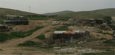
Bedouin Encampment

A Bedouin encampment with semi-permanent structures.

Meanwhile, Israel is widening the road, building a second lane to provide higher speed access to the Jordan Valley. Slicing straight through the hill, the roadwork reveals interesting patterns of twisted layers of rock.

Twisted strata exposed by construction.
More twisted strata.

Passing the sea level marker, each few miles takes us deeper and deeper.

Now passing 150 meters below sea level

Now, we start seeing settlements again. First we pass Mitzpeh Yericho (Jericho View.)


Mitzpeh Yericho
More Bedouin shepherding and camel farming.

Then we pass Vered Yericho (Jericho Rose,) and we're coming up on Jericho.

Vered Yericho

Turning the corner, the jagged mountains suddenly give way to the Jordan Rift Valley. Flat, hot, dusty, and dead. To our left is the city of Jericho. Jews used to travel through Jericho on their way. That was before the peace process, and before the second intifadah. Despite Jericho's reputation as being too hot and languid for politics, today, Jericho is a closed, Arab-only city. Jews enter only at great personal risk.

Jericho in the distance. Israel has since built a winding bypass road to avoid the city.

Camels and pottery sales at the road's edge.


Eventually we reach our stop, "Machaneh Nevo" (Nebo Camp.) Soldiers disembark for their base, a border guard station, and we head for our farm. Directly across us is Har Nevo (Mount Nebo,) the mountain where Moshe (Moses) dictated the book of Devarim (Deuteronomy,) and was shown the entire land of Israel, before his death.


The bus continues to Beit She'an, leaving us in the desert.
Walking to the farm, we pass a graveyard of border fortifications, barricades, and pillboxes.


Mahaneh Nevo, the army border guard camp.

Coming up next... Beit Hogla.

Thursday, April 19, 2007

Holocaust Remembrance Day

A couple of days ago was Holocaust Remembrance Day, which falls on the 27th of Nisan, kicking off a week of Holocaust-related ceremonies and remembrances. For me, I must admit, it's a struggle to really get into the Holocaust spirit. Part of the problem is with Halachah (Jewish religious practice.) During the month of Nisan, the month of Passover celebrating the liberation from slavery, public mourning is not permissible. Israel's founding fathers, believing Judaism to be on its way into the history books, to be replaced with Socialist Zionism, were not too concerned about what they considered halachic trivialities when they set the date for the holiday. After all, Independence was declared in Nisan, and Holocaust day had to be set before Independence Day in order to prove that Israel is the answer to the Holocaust. Being of the National Religious persuasion, participating in the daily life of the country without surrendering Torah observance, is particularly difficult on such days. The Haredi (ultra-orthodox) response has been to completely ignore the holiday, mourning the Holocaust instead on Tisha B'Av, the traditional day of mourning for the destruction of the second temple, and all other calamities that have befallen us. When the siren sounds and the rest of the country pulls over to the side of the road, or stops whatever they are doing to stand at attention, many within the Haredi communities simply keep right on moving with the day's business.

Part of my own discomfort comes from the focus on the Holocaust-ism as a substitute for Judaism I felt growing up. The majority (albeit a shrinking majority) of Jews in America no longer understand Hebrew, live by Torah precepts, or share common goals, so the Holocaust has become an identity-crutch for most. Since the only thing all Jews in America still have in common is that Hitler would have murdered them, that's really all there is to talk about. After I completed my Bar Mitzvah, an entire year of our Hebrew school was devoted to Holocaust Studies. That was the year everyone dropped out.

In Israel, the problem is different. In Israel it's not just "Holocaust Remembrance Day," but "Holocaust Martyrs and Heroes Remembrance Day." The nationalist fighting ethic which originally energized the Zionists led them to look down on the Holocaust survivors as weaklings who were led as "sheep to the slaughter." Holocaust survivors who came to Israel were labeled with the pejorative, "soap," a reference to the Nazis' supposed conversion of the human fat of their victims into soap. These "soap" Jews embodied every stereotype of weakness and passivity the "New Jews" of Israel thought the Europeans despised in them, Europeans whom they strangely emulated and from whom they sought admiration.

While the Israeli hostility towards Holocaust survivors has certainly dissipated with the advent of post-Zionism, I still hear the occasional, "Why didn't they fight back?" from Israelis, as if the Jewish Shtetls of Poland were as flooded with M-16s and military hardware as Israel is today. Perhaps the most disconcerting is when Israel's leadership somberly stands at attention at various Holocaust ceremonies and firmly states "never again," and of the "need to learn the lessons of the Holocaust." It's not the sentiment that irks me so much as the hypocrisy. The day before, the Prime Minister was meeting with Dr. Mahmoud Abbas, Chairman of the Palestinian Authority, whose very charter calls for another Holocaust on the Jews. And never mind that Abbas himself wrote his PhD thesis as a work of Holocaust denial, claiming that the Holocaust was invented by the Zionists for propaganda purposes.

Despite religious misgivings and my own discomfort, I certainly think it's important that survivors see that such an personal and national catastrophe isn't just a footnote in the history books. When the siren sounded at 10AM, I stopped what I was doing, which happened to be sitting in my apartment in my pajamas filling out California Building Code compliance forms. I stepped outside and stood at attention in my slippers. While the siren wailed on for a full minute, I looked out over row after row of massive apartment blocks hugging the succeeding ridgelines, my ridgeline being Pisgat Ze'ev East, the next being Pisgat Ze'ev Central, and beyond that, Pisgat Ze'ev North and behind the dusty haze, Neve Ya'akov, off miles in the distance. With my mind still in building code number-crunching mode, I had a horrible thought. The total population I could see, from where I stood to Neve Ya'akov in the hazy distance, is 60,000 people. On a "good" day, Auschwitz could get rid of 12,000 people. That is to say, all of Pisgat Ze'ev and Neve Ya'akov would be 5 days, a standard workweek, for the SS. In total, over 100 Pisgat Ze'evs were destroyed. But the thought doesn't make me sad, it makes me want to build another 200 in their place.

A small section of Pisgat Ze'ev North

Wednesday, April 18, 2007

A Day on the Streets of Jerusalem

I took a tour downtown today of the old neighborhoods of Yemin Moshe, Nachlaot, and saw the prison where the fighters of the Jewish underground were incarcerated and killed by the British. The prison part was pretty grim. Perhaps I'll post it for Yom Hazikaron (Israeli Memorial Day, next week.)

Meanwhile, here are some photos I took just strolling around Jerusalem:


Excavations at the Mugrabi Gate. The excavations have been a site of some controversy. The Islamic Movement in Israel (that is, radical Islamic fundamentalists who live inside Israel with Israeli citizenship) tried to stir up riots about a month ago, claiming Israel was trying to tear out the foundations of the Temple Mount. You can see the Temple Mount about a hundred feet behind them, which is obviously nowhere near the excavations. But it served its purpose. Israel invited the Turkish government to mediate and oversee the excavations, so the Islamic Movement had a small victory.


A group of Japanese tourists at the Kotel.

The finance minister increased tuition payments, so the university students went on strike. One would typically think of picket lines or traffic obstruction for a strike, but these are students, not auto workers, so they had a techno-trance in Kikar Tzion instead.

I bumped into Baruch downtown. Baruch used to study at Machon Meir. He's now working at the King David Hotel (which, by the way, was the British military headquarters in the 1940's until it was blown up by the Jewish Underground, mentioned previously.)

Some of the strangest picket signs I've ever seen.
Back in Pisgat Ze'ev, people are getting ready for Lag B'Omer, the 33'rd day of the 49-day long period of counting known as the "Omer" (today is day 15.) Lag B'omer is celebrated with massive bonfires, so the children are going out into the fields and bringing back shopping carts loaded with wood in anticipation.
Looking out at the Hills of Binyamin (the tribal region of Benjamin,) and the Ramallah Bypass Road, from my street. In the distance is the Jordan Valley.

Today begins the Jewish month of Iyar. Chodesh Tov!