On our way back from the Golan Heights (which I'll post about once I can get my photos together,) we stopped by the tiny agricultural outpost of Beit Hoglah for Ma'ariv (evening prayers.)
The new month of Nisan is so intense, with Pesach (Passover) and all, that the yeshivot let their students off for a month-long break. Some of the students had signed up to volunteer at Beit Hoglah, and so jumped off the bus while the rest of us headed back for Jerusalem. Ze'ev (one of my fellow yeshivah students) had mentioned, while at Beit Hoglah, that there was going to be some sort of rally there next month, so I later called him for an exact date.
"You coming for Shabbat?"
"Sure."
So I was signed up. Minutes later, Adam Neril, one of my fellow Walnut Creek olim, gave me a call.
"What are you doing for Shabbat?"
"Going to Beit Hoglah."
"Where's that?"
"The end of the world."
"Can I come too?"
"No problem."
And so it went. Pretty soon, there were fourteen of us signed up.
The route to Beit Hogla
Adam and I met up at the bus station and caught the early bus, before the rest of the group.
Adam, learning the parts of the human body in Hebrew from a kid's book. He's studying to be an EMT (emergency medical technician.)
Driving east from Jerusalem, and down in altitude, we pass through the Mount
Scopus tunnel and emerge in the desert, now green from the winter's rain. Route 1, which connects Tel
Aviv to Jerusalem, was extended after 1967 all the way through Jericho. East of Jerusalem, the massive settlement of
Ma'aleh Adumim (Red Heights,) with over 25,000 people, until this year the largest settlement of them all, clings to the hilltops. Taking its name from the distinctly red-hued earth in the region,
Ma'aleh Adumim is referenced in the
Sefer Yehoshua (the
Book of Joshua,)
15:6-18, as the border region between the territory of the tribes of
Yehudah (Judah) and
Binyamin (Benjamin.) The land between
Ma'aleh Adumim and Jerusalem is the E1 corridor.
East or west, up or down?
Surrounded in
contraversy (as if anything in this country weren't,) the E1 corridor is an empty swath of desert smaller than George Bush's Crawford ranch which not only connects
Ma'aleh Adumim to Jerusalem, but also the Arab settlements north of Jerusalem in the
Ramallah area to those south of Jerusalem in the
Beit Lechem (Bethlehem) area. The Arabs want to build in the area in order to block off the possibility that
Ma'aleh Adumim, and the Jordan River Valley below, will become part of Israel. Israel wants to build there for the same reason, as well as to relieve the population pressure of a rapidly growing Jerusalem. So now, the American referees have stepped in and forced Israel to freeze building plans for the time being. But the Jerusalem municipality did move its massive police station out there, selling the original one on the
Mount of Olives to
Ateret Cohanim.
The East Jerusalem Police Station, relocated from Har Hazeitim (The Mount of Olives)
Rolling along on our merry way, the reclaimed forests and thickly settled Jerusalem suburbs gradually give way to grassy hills and more isolated settlements. Passing by Kfar Adumim (Red Village,) a smaller Jewish village in the region.
Kfar Adumim. Sadly, in a month or so, all this grass will be dead, and the air will again fill with dust until next winter.
 Kfar Adumim and a little industrial area in the foreground.
Now entering the empty region between the suburbs of Jerusalem and Jericho, the grass grows thinner and thinner. Alongside the road one sees many Bedouin encampments. Over the past decades, the Palestinian Authority has pumped funds to pay the Bedouin, traditionally wandering nomadic people, to settle more permanently in the region and shift the demographics against Israel's favor. While the Bedouin themselves tend to remain apolitical, the financial incentives are having a pronounced effect.
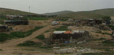 Bedouin Encampment
 A Bedouin encampment with semi-permanent structures.
Meanwhile, Israel is widening the road, building a second lane to provide higher speed access to the Jordan Valley. Slicing straight through the hill, the roadwork reveals interesting patterns of twisted layers of rock.
 Twisted strata exposed by construction.
 More twisted strata.
Passing the sea level marker, each few miles takes us deeper and deeper.
 Now passing 150 meters below sea level
Now, we start seeing settlements again. First we pass
Mitzpeh Yericho (Jericho View.)
 Mitzpeh Yericho
 More Bedouin shepherding and camel farming.
Then we pass Vered Yericho (Jericho Rose,) and we're coming up on Jericho.
 Vered Yericho
Turning the corner, the jagged mountains suddenly give way to the Jordan Rift Valley. Flat, hot, dusty, and dead. To our left is the city of Jericho. Jews used to travel through Jericho on their way. That was before the peace process, and before the second intifadah. Despite Jericho's reputation as being too hot and languid for politics, today, Jericho is a closed, Arab-only city. Jews enter only at great personal risk.
 Jericho in the distance. Israel has since built a winding bypass road to avoid the city.
 Camels and pottery sales at the road's edge.
Eventually we reach our stop, "Machaneh Nevo" (Nebo Camp.) Soldiers disembark for their base, a border guard station, and we head for our farm. Directly across us is Har Nevo (Mount Nebo,) the mountain where Moshe (Moses) dictated the book of Devarim (Deuteronomy,) and was shown the entire land of Israel, before his death.
 The bus continues to Beit She'an, leaving us in the desert.
 Walking to the farm, we pass a graveyard of border fortifications, barricades, and pillboxes.
 Mahaneh Nevo, the army border guard camp.
Coming up next... Beit Hogla.


 Kfar Adumim and a little industrial area in the foreground.
  A Bedouin encampment with semi-permanent structures.
  Twisted strata exposed by construction.
 More twisted strata.
 Mitzpeh Yericho
 More Bedouin shepherding and camel farming.
 Camels and pottery sales at the road's edge.
 Walking to the farm, we pass a graveyard of border fortifications, barricades, and pillboxes.
 Mahaneh Nevo, the army border guard camp.
No comments:
Post a Comment